TODAY’S MESSAGE: Yesterday, a finger of the Pagami Creek Fire made an unprecedented 16 mile run to the east, reaching the edge of Polly Lake. The fire became a plume-driven event and reached in excess of 60,000 acres. The fire is now under Unified Command with Lake County Sheriff’s Office as full partners of management of this fire. Residents were evacuated from 36 addresses along the portion of the Cramer Road/Lake County Road 7 from Kawishiwi Lake south to the Wanless Road (Forest Road 172) and along the Wanless Road west from the junction with the Cramer Road to Homestead Lake. Public Safety crews continue to range the wilderness, moving visitors out of areas where they may be at risk. A town meeting held in Isabella was attended by about 100 concerned residents. Winds are expected to be strong and out of the northwest and west again today with little or no precipitation expected.
ACTIVITIES TODAY:
Hand crews on the north side of the fire will be patrolling lines and monitoring for any fire spread
Airplanes and helicopters are being used to drop water to slow the spread of the fire.
Areas around the fire within the BWCAW are being assessed to plan for visitor evacuation and closure.
A Community Meeting will be held at the Vermilion Community College in Ely, Minnesota tonight, September 13, 2011 at 7:00 p.m.
Daily public meetings will be held in Isabella Community Center at 11:00 a.m.
A Joint Information Center has been set up in the Kawishiwi Ranger District Office for answering both Superior National Forest and Lake County questions.
BWCAW CLOSURES: Closures will be added soon. A complete list will be sent out soon.
ROAD CLOSURES: All roads north of the following route are closed: Highway 1 from Forest Road (FR) 1468 east to Isabella; Wanless Road (FR 172) east to Lake County Road 7; Lake County Road 7 north to FR 354; FR 354 north to BWCAW boundary at Kawishiwi Lake. Highway 1 is still open. Road blocks staffed within Lake County will be at the intersections of Wanless and Cramer, Highway 1 and Wanless, Hwy 1 and Tomahawk Trail. Road blocks within Cook County will be Hwy 3 just west of Sawbill Road. Additional closures may occur.
SAFETY: The Superior National Forest and the Minnesota Department of Natural Resources are enacting additional fire restrictions for areas outside the BWCAW. Go to the MNICS.org and the Superior National Forest websites for further information.
DATE OF DETECTION: August 18, 2011
CAUSE: Lightning
CURRENT SIZE: in excess of 60,000 acres
LOCATION: Township 63 N, Range 9 W, approximately 14 miles east of Ely (within the Boundary Waters Canoe Area Wilderness) in the Pagami Creek area between the South Kawishiwi River, Clearwater Lake, and Lake One.
AGENCY: Superior National Forest, Kawishiwi Ranger District
SMOKE CONDITIONS: Smoke may be heavy and wide spread depending on wind direction.
RESOURCES: Nearly 200 personnel are assigned to the fire.
ADDITIONAL INFORMATION:
Phone (218) 365-3177

Tuesday, September 13, 2011


Monday, September 12, 2011
Pagami Creek Fire - Sept. 12 Update
TODAY’S MESSAGE: Yesterday, strong north winds drove a point of the Pagami Creek Fire south toward the Isabella River. Approximately 50 campers from the river and lake routes south of the fire and 70 campers along the eastern front of the fire were assisted out of the wilderness by Public Safety Crews. Entry points near the fire were closed and campers with reservations were given the option to reserve a new permit with available quota from other entry points. Wilderness wide campfire restrictions were enacted. Campfires will be allowed only between 6:00 p.m. and midnight until further notice.
ACTIVITIES TODAY: Public Safety crews are posted at portages and entry points to keep visitors clear of areas threatened by fire as well as those areas that may fill with dense smoke. Airplanes and helicopters are being used to drop water, keeping the fire within the wilderness and south and east of the Kawishiwi River. Crews will focus containment efforts on the northern edge and southern tip of the fire.
CLOSURES: Most of the BWCAW remains safe and open to visitors. To insure public safety the following waterways and portages are closed: Lakes One through Hudson, Fire, Bridge, Rifle, the Wilders, Horseshoe, Pagami, Clearwater, Turtle, Camdre, Pietro, Gull, Quadga, Rice, Isabella Lake, and the Isabella River. The southern campsites on Bald Eagle are closed. The Pow Wow Trail is closed. The following entry points are closed: #30 Lake One, #84 Snake River, #75 Little Isabella River, #67 Bog Lake, #86 Pow Wow Trail, #35 Isabella Lake, and #34 Island River. Today, campsites on the southern end of Insula Lake will be added to the closures. Sites, routes and portages will be re-opened as soon as it is safe to do so.
SAFETY: Public Safety crews will be working with campers in nearby lakes including Insula to advise them of safe travel routes. Campfire restrictions are in place. In the entire BWCAW campfires are allowed only between 6 p.m. and midnight. Be sure that campfires are doused thoroughly until cold to the touch.
DATE OF DETECTION: August 18, 2011
CAUSE: Lightning
CURRENT SIZE: approximately 11,000 acres--acreage is expected to increase today due to weather conditions.
LOCATION: Township 63 N, Range 9 W, Sections 30, 31, 32: approximately 14 miles east of Ely (within the Boundary Waters Canoe Area Wilderness) in the Pagami Creek area between the South Kawishiwi River, Clearwater Lake, and Lake One.
AGENCY: Superior National Forest, Kawishiwi Ranger District
SMOKE CONDITIONS: Smoke may be heavy and wide spread depending on wind direction. RESOURCES: A 20 person Minnesota Incident Command System crew of firefighters arrived last night. Another crew is on order. Yesterday, we received assistance from a Canadian air tanker. A helicopter and a CL-215 air tanker are at the Ely tanker base.
ADDITIONAL INFORMATION: Phone (218) 365-3177 Internet: www.inciweb.org/incident/2534
ACTIVITIES TODAY: Public Safety crews are posted at portages and entry points to keep visitors clear of areas threatened by fire as well as those areas that may fill with dense smoke. Airplanes and helicopters are being used to drop water, keeping the fire within the wilderness and south and east of the Kawishiwi River. Crews will focus containment efforts on the northern edge and southern tip of the fire.
CLOSURES: Most of the BWCAW remains safe and open to visitors. To insure public safety the following waterways and portages are closed: Lakes One through Hudson, Fire, Bridge, Rifle, the Wilders, Horseshoe, Pagami, Clearwater, Turtle, Camdre, Pietro, Gull, Quadga, Rice, Isabella Lake, and the Isabella River. The southern campsites on Bald Eagle are closed. The Pow Wow Trail is closed. The following entry points are closed: #30 Lake One, #84 Snake River, #75 Little Isabella River, #67 Bog Lake, #86 Pow Wow Trail, #35 Isabella Lake, and #34 Island River. Today, campsites on the southern end of Insula Lake will be added to the closures. Sites, routes and portages will be re-opened as soon as it is safe to do so.
SAFETY: Public Safety crews will be working with campers in nearby lakes including Insula to advise them of safe travel routes. Campfire restrictions are in place. In the entire BWCAW campfires are allowed only between 6 p.m. and midnight. Be sure that campfires are doused thoroughly until cold to the touch.
DATE OF DETECTION: August 18, 2011
CAUSE: Lightning
CURRENT SIZE: approximately 11,000 acres--acreage is expected to increase today due to weather conditions.
LOCATION: Township 63 N, Range 9 W, Sections 30, 31, 32: approximately 14 miles east of Ely (within the Boundary Waters Canoe Area Wilderness) in the Pagami Creek area between the South Kawishiwi River, Clearwater Lake, and Lake One.
AGENCY: Superior National Forest, Kawishiwi Ranger District
SMOKE CONDITIONS: Smoke may be heavy and wide spread depending on wind direction. RESOURCES: A 20 person Minnesota Incident Command System crew of firefighters arrived last night. Another crew is on order. Yesterday, we received assistance from a Canadian air tanker. A helicopter and a CL-215 air tanker are at the Ely tanker base.
ADDITIONAL INFORMATION: Phone (218) 365-3177 Internet: www.inciweb.org/incident/2534
BWCA Fire Restrictions Effective Today

I snapped this photo of the Fire Danger sign outside the USFS Kawishiwi Ranger District office yesterday.
Sunday, September 11, 2011
Pagami Creek Fire in BWCAW - Sept. 11, 2011
TODAY’S MESSAGE: Yesterday’s dry air and north winds pushed the Pagami Creek Fire farther south yesterday. In consideration of today’s high fire indices, fire managers began a proactive movement of campers from Lakes Two through Hudson, nearby routes, and the Isabella River within the Boundary Waters Canoe Area Wilderness (BWCAW). Specific closures are listed below. Most of the BWCAW remains safe and open to visitors eager to enjoy the fall season.
ACTIVITIES TODAY:
Public Safety crews are sweeping the areas to be closed, assisting campers into other lakes.
Airplanes and helicopters are being used to drop water, keeping the fire within the wilderness and south and east of the Kawishiwi River.
CLOSURES: The vast majority of the BWCAW remains safe and open to visitors. To insure public safety the following waterways and portages are temporarily closed: Lakes One through Hudson, Fire, Bridge, Rifle, the Wilders, Horseshoe, Pagami, Clearwater, Turtle, Camdre, Pietro, Gull, Quadga, Rice, Isabella Lake, and the Isabella River. The southern campsites on Bald Eagle are closed. The Pow Wow Trail is closed. Sites, routes and portages will be re-opened as soon as it is safe to do so. The following entry points are closed: #30 Lake One, #84 Snake River, #75 Little Isabella River, #67 Bog Lake, #86 Pow Wow Trail, #35 Isabella Lake, and #34 Island River. Campers already in the BWCAW will be able to travel through these routes to exit the wilderness but visitors will not be allowed to enter at these points until further notice.
SAFETY: Campfire restrictions are in place. Wilderness wide, campfires are allowed only between 6 p.m. and midnight. Be sure that campfires are doused thoroughly until cold to the touch.
DATE OF DETECTION: August 18, 2011
CAUSE: Lightning
CURRENT SIZE: approximately 4500 acres burned. Acreage is expected to increase today due to weather conditions.
LOCATION: Township 63 N, Range 9 W, Sections 30, 31, 32: approximately 14 miles east of Ely (within the Boundary Waters Canoe Area Wilderness) in the Pagami Creek area between the South Kawishiwi River, Clearwater Lake, and Lake One.
AGENCY: Superior National Forest, Kawishiwi Ranger District
SMOKE CONDITIONS: Smoke may be heavy and wide spread depending on wind direction.
RESOURCES: The fire is now under the management of Type 2 Incident Management Team Hinds.
ADDITIONAL INFORMATION:
Phone (218) 365-3177
Internet: www.inciweb.org/incident/2534
Saturday, September 10, 2011
Pagami Creek Fire in BWCA Prompts Temporary Closures
Unseasonably dry, warm conditions and low relative humidities yesterday allowed the Pagami Creek Fire to burn actively south of the Lakes One and Two area. The burn out operation conducted last weekend was successful in reducing the threat of the fire escaping the Boundary Waters Canoe Area Wilderness (BWCAW) and threatening the Fernberg corridor to the north.
To provide for public safety the Superior National Forest is temporarily closing the following:
- As a precautionary measure Lakes Two and Three will be closed. [Note the Forest Service has clarified that travel will be allowed through Lakes Two and Three, but no overnight camping will be allowed there.] Visitors currently in that area will be contacted by public safety crews. Alternatives include returning to Lake One for those leaving the area before Monday. Visitors who will be in the Wilderness beyond Monday are asked to head east into Lake Four or beyond. People intending to visit Lake One are encouraged to find other plans or paddle on the Kawishiwi River.
- All campsites on Clearwater Lake
- The portage between Lake Two and Clearwater Lake
- The portage between Turtle Lake and Clearwater Lake - The portage between Camdre Lake and Clearwater Lake
- The Powwow Trail Public Safety crews will be contacting BWCAW visitors in affected areas to alert them of any safety concerns.
As the Pagami Creek Fire moves south it is continuing to provide resource management benefits such as preparing seed beds for pine regeneration and decreasing fuels for future wildfires. As the fire burns to the south it is reaching older burned areas. These earlier burns may function like fuel breaks and decrease the likelihood of the fire moving further south.
Paddlers are asked to avoid the fire area. People throughout northeastern Minnesota have been experiencing smoke from the Pagami Creek Fire. The increase in fire activity means an increase in smoke as well. The location of the smoke will be dependent on wind direction. Anyone with a history of cardiac or respiratory disease should be aware that visitors to the Lakes One, Two and Three area are likely to experience heavy smoke at times.
Persistent warm, dry conditions have raised the fire danger throughout the area. Visitors are reminded to be careful with all fire use and ensure that their campfires doused thoroughly until cool to the touch.
For additional information please call (218) 365-3177 or visit www.inciweb.org/incident/2534
To provide for public safety the Superior National Forest is temporarily closing the following:
- As a precautionary measure Lakes Two and Three will be closed. [Note the Forest Service has clarified that travel will be allowed through Lakes Two and Three, but no overnight camping will be allowed there.] Visitors currently in that area will be contacted by public safety crews. Alternatives include returning to Lake One for those leaving the area before Monday. Visitors who will be in the Wilderness beyond Monday are asked to head east into Lake Four or beyond. People intending to visit Lake One are encouraged to find other plans or paddle on the Kawishiwi River.
- All campsites on Clearwater Lake
- The portage between Lake Two and Clearwater Lake
- The portage between Turtle Lake and Clearwater Lake - The portage between Camdre Lake and Clearwater Lake
- The Powwow Trail Public Safety crews will be contacting BWCAW visitors in affected areas to alert them of any safety concerns.
As the Pagami Creek Fire moves south it is continuing to provide resource management benefits such as preparing seed beds for pine regeneration and decreasing fuels for future wildfires. As the fire burns to the south it is reaching older burned areas. These earlier burns may function like fuel breaks and decrease the likelihood of the fire moving further south.
Paddlers are asked to avoid the fire area. People throughout northeastern Minnesota have been experiencing smoke from the Pagami Creek Fire. The increase in fire activity means an increase in smoke as well. The location of the smoke will be dependent on wind direction. Anyone with a history of cardiac or respiratory disease should be aware that visitors to the Lakes One, Two and Three area are likely to experience heavy smoke at times.
Persistent warm, dry conditions have raised the fire danger throughout the area. Visitors are reminded to be careful with all fire use and ensure that their campfires doused thoroughly until cool to the touch.
For additional information please call (218) 365-3177 or visit www.inciweb.org/incident/2534
Thursday, September 1, 2011
A Win for Wild Horizons in the Wilderness

When AT&T failed to respond to the Friends' request, the Friends filed suit in Minnesota State Court claiming violation of Minnesota environmental laws.
We're happy to have supported the Friends in this effort to preserve the special wild horizons of the spectacular Boundary Waters. We're also proud to have served a small role in the lawsuit process. In January, I guided the expert surveyor on the case by dogsled to remote parts of the BWCAW. We traveled over frozen (and at times slush-covered) lakes and snow-covered portages to obtain special survey readings to present as evidence at trial.
The case went to trial this late spring and the judge recently made his ruling. The decision is a clear win for the Friends and the importance of wild horizons in the BWCAW. The ruling expressly prohibits the 450' tower.
The Judge's decision is worth the read, making a strong argument for the special value of wilderness. You can download the ruling (large 6 MB file) and read it for yourself.
The judge concludes that a 199-foot, unlighted tower, which he explicitly allowed in his ruling, would serve all the same residences outside of the BWCAW. The judge also discussed the significant impact the proposed tower would have had: "The scenic views and vistas from within the BWCAW are rare, unique, endangered and of great historical significance. This factor weighs very strongly against construction of the Proposed Tower."
You can support the Friends of the Boundary Waters and their efforts to protect our beloved part of the world by becoming a member and donating money. Without this important advocacy group, no other organization exists to effectively speak up for the Wilderness and the importance of preserving its wild character. Many challenges still face the Wilderness, including the threat of water pollution from new sulfide mining proposals at the edge of the Boundary Waters, and the Friends are the foremost watchdog providing good information and advocacy on these issues.
This photo was snapped recently by Ely Outfitting Company guests Nate and Linda Ferris on Quadga Lake in the BWCA. What a shame if such sunset views were impaired by a glaring red flashing light. Thankfully, committed professionals are working to protect these viewscapes.
Wednesday, August 31, 2011
Protect Collared Research Black Bears

An anonymous party is offering a Jackpot of $5000 to black bear hunters in Minnesota. The Jackpot is being offered in order to help protect the black bears being researched by Dr. Lynn Rogers of the National Bear Center and the Wildlife Research Institute in Ely, Minnesota. The benefactors are offering the prize to every hunter who has a valid black bear permit for the 2011 bear hunting season in bear hunting areas 22, 24, 25 and 31.
The drawing is intended to reward hunters for refraining from shooting the 8-20 radio collared research bears with or without brightly colored tape or ribbons attached to their collars, so that valuable data from those bears is not lost. The benefactors are hoping that if a hunter enters the drawing, they will be less likely to shoot a collared bear, because it would invalidate the drawing. They are also hopeful that every hunter who enters the drawing will ask their fellow hunters not to shoot the bears, and that they in turn will enter the drawing. The sponsors see this as a non-judgmental, simple, direct, and hopefully effective way to discourage shooting the research bears. It is not an effort to stop bear hunting in Minnesota, because the benefactors realize that hunting is a needed management tool, which is used to keep the number of bears in Minnesota in balance with both the carrying capacity and the human social acceptance capacity of the land.
To be eligible to win the Jackpot, hunters must send a copy of their permit to entry@bearhuntersjackpot.com or have their permit photographed by volunteers while they are in those hunting areas, before or during the 2011 bear hunting season. The volunteers will then enter the permits into the drawing. After the hunting season is over, the drawing will be held using a random number process and the winner will be sent a cashier’s check for $5000. However, the Jackpot will only be offered if none of the research bears are shot or wounded during the hunting season. The email addresses and names of the entrants will be held in confidence and will not be used for any other purpose than the drawing.
Monday, August 15, 2011
Bald Eagles in the BWCAW
 Nevada Smith and his family recently paddled up to Lac la Croix for a week. The guys were fishing and saw this bald eagle intently watching them. Eventually, after much successful fishing of their own, they watched as the bald eagle came soaring down, scooped a fish out of the water they had recently caught and landed back in its trees near their campsite. The guys continued to watch as it ate the small fish. There's nothing quite like a fresh fish meal, for people or for eagles. Thanks to Nevada for sharing his photos here on Boundary Waters Blogger!

Monday, July 25, 2011
Sunday, July 24, 2011
How to Handle Heat in the Boundary Waters
This is how we managed the scorching heat on trail in the BWCA this week.


Thursday, July 21, 2011
Fishing Licenses Available Again

As of this morning, the Minnesota government is back up and running. Fishing licenses are for sale again, both online and in person. Perfect time to plan your Boundary Waters vacation and do a little (or a lot!) of fishing!
Wednesday, July 20, 2011
Another Successful Women's Guided Canoe Trip in the Boundary Waters

I just finished guiding a great group of three ladies in the Boundary Waters. These women have known each other for years. They were always a little jealous of their husbands' canoeing trips, and thought this could be their chance. We were out for three days, and enjoyed excellent, sunny weather. We were surprised to see a handful of other women's groups. It appears that more women are getting turned on to what the wilderness can offer. Some of those young women were part of a youth group out for eleven days (you go, girls!).
My three ladies proved themselves to be very quick learners, taking to the paddling and steering well. We portaged the couple of trails to our destination lake without too much trouble.
 Roxanne and Jean had heard stories from their husbands, and put forth a great effort. Jean paddled like a rock star, and Roxanne kept us laughing. Sunn, originally from China, was a champ at carrying packs or the canoe. She kept us engaged with stories of her interesting childhood.
These ladies expressed feelings before the trip like many of our guided trip folks, feeling a little less than confident upon starting but inspired nonetheless. With a great attitude and plenty of teamwork, our group of four succeeded! These women had in mind taking it easy (can't beat a hammock in the shade!) and seeing what this wilderness area is all about.
 This baby loon with its parents put a smile on all of our faces on our afternoon trip...

... as did this late-blooming wild iris we found hiding on a shady shoreline.

Women's Trips are a great way to get out there, be part of nature, get to know your friends better, meet new people, and find yourself in a new light. We are offering a Women's Group Trip this September 7-11. This trip is a perfect way to experience the Boundary Waters as comfortably as possible and meet other adventurous women. Cost is a very reasonable $620. More information can be found on our website here. We'd love to have you and your friends come along with us!

Monday, July 18, 2011
Newest Book on Dorothy Molter

The authors behind the latest book on Dorothy Molter, the Root Beer Lady of Knife Lake in the BWCAW, are having a Book Release and Signing Party at the Dorothy Molter Museum. Come on out this Friday from 4 pm to 8 pm.
Sunday, July 17, 2011
Blueberries are Ripening in the Boundary Waters

Saturday, July 2, 2011
Kids and Watercolor in the Boundary Waters

Josie (age 10, from Wisconsin), painted these pictures while on a BWCA canoe trip this week with her younger brother and parents. Her savvy mom packed along a backpacking style watercolor kit for her kids.
Sure enough, they found plenty of subjects to paint. The above Bald Eagle perched contently at the top of a tree right in their campsite. The loon painted below also approached them. It came within about a paddle's length of their canoe - close enough to see the loon's deep red eyes and how big the birds really are.
Thanks to Josie for sharing her watercolors! And thanks to her whole family for joining Ely Outfitting Company for an outfitted canoe trip.

Thanks to Josie for sharing her watercolors! And thanks to her whole family for joining Ely Outfitting Company for an outfitted canoe trip.


Wednesday, June 29, 2011
Dragonflies Emerging From Fourtown Lake in the BWCAW

One of the great things about late spring and early summer in the Boundary Waters is the overwhelming sign of new life. It seems everywhere you look there are birds on nests or with young in tow, flowers cover the forest floor, and insects such as these dragonflies are emerging to a new life of flight.
We spotted a mass of hundreds of these dragonflies at the north end of Fourtown Lake in and around the reeds where the stream flows into the main lake. These dragonflies spent possibly several years underwater in a nymph stage. Then they crawled out of the water to a vertical surface - reads and blades of grass here. Although they are difficult to positively ID at this stage, this dragonfly may be a member of the Baskettails genus that are known for mass emergences, a brown abdomen, and yellowish spots on their sides. The below photo shows one of them back lit in the reads.

The larval case that the above dragonfly is clinging to contained all of the much larger adult dragonfly body and wings earlier in the day. It emerged from a break in the skin at the back of the head of the larval case, then pulled itself out, pumped blood into its wings to expand them, and waited for its wings to dry and its body to complete the metamorphosis.
Although this dragonfly didn't take flight during our lunch stop, we watched a similar dragonfly emerge in our earlier campsite on Lake Agnes, and luckily caught a glimpse of its first flight. The flight pattern looked erratic and dizzyingly loop-d-loop for the first twenty feet, and then it seemed to get the feel of flying and buzzed back into the woods.
After dragonflies take flight, the empty larval shell, such as the one below, clings to the plant, rock or occasional camp utensil bag until the wind or rain knocks them loose.


Friday, June 24, 2011
Turtles are Venturing into BWCA Campsites to Lay Eggs Now


Sunday, June 19, 2011
Father and Son Boundary Waters Canoe Trip
I spent a week in the BWCAW with Gary and his 18-year-old son, Blake, this month. As a young Boy Scout in 1970, Gary traveled the Boundary Waters. His youthful canoe trip experience really left a life-long impression on him. He wanted his son to have a similar opportunity to explore the wilderness as a young man.


We planned a significant travel route for the trip - one that would challenge them physically and include travel on a variety of small, medium, and large lakes. The trip launched at the Moose River North (Entry Point 16) landing, and ended six days, and fifty miles, later at the Mudro Lake entry point. One of the highlights of the route is spectacular Curtain Falls (below) on the international border.

June is a glorious time to be in the Boundary Waters. It is a time of much new growth and change. The symbol of change is similar to that of a young man transitioning from life at home to moving away for college.
One of the intriguing things about traveling at this time of year is that you see plants at all stages of development. Gary and Blake enjoyed learning about the various plants of the area. Depending on soil types and locations, we saw many plants at different stages of development. For example, we passed many Clintonia plants (below). We saw them just poking through the ground, at a stage of larger leaves, and also with their yellowish-green flowers. Later this summer the flower will be replaced by a blue berry.


Although the berry is not edible, the young leaves are edible and taste a lot like cucumber. Blake is a fan of the Survivor Man television show and enjoyed learning about edible wilderness plants, and eating them.

Another one of the interesting plants we saw at various stages of growth is the sarsaparilla plant. This is the "not poison ivy" plant. It is often confused with poison ivy because it has three leaves at the end of its stems. When it is young, the leaves have a reddish hue, and then they become green, and grow interesting spheres of flowers (below).


And the ferns ranged from the stage of youthful, unfurling fiddleheads to showing as fully opened.


We also saw a variety of spectacular wildflowers, including these bunchberry plants, now showing their white flowers....

...and these pink ladyslippers...


...and this columbine.

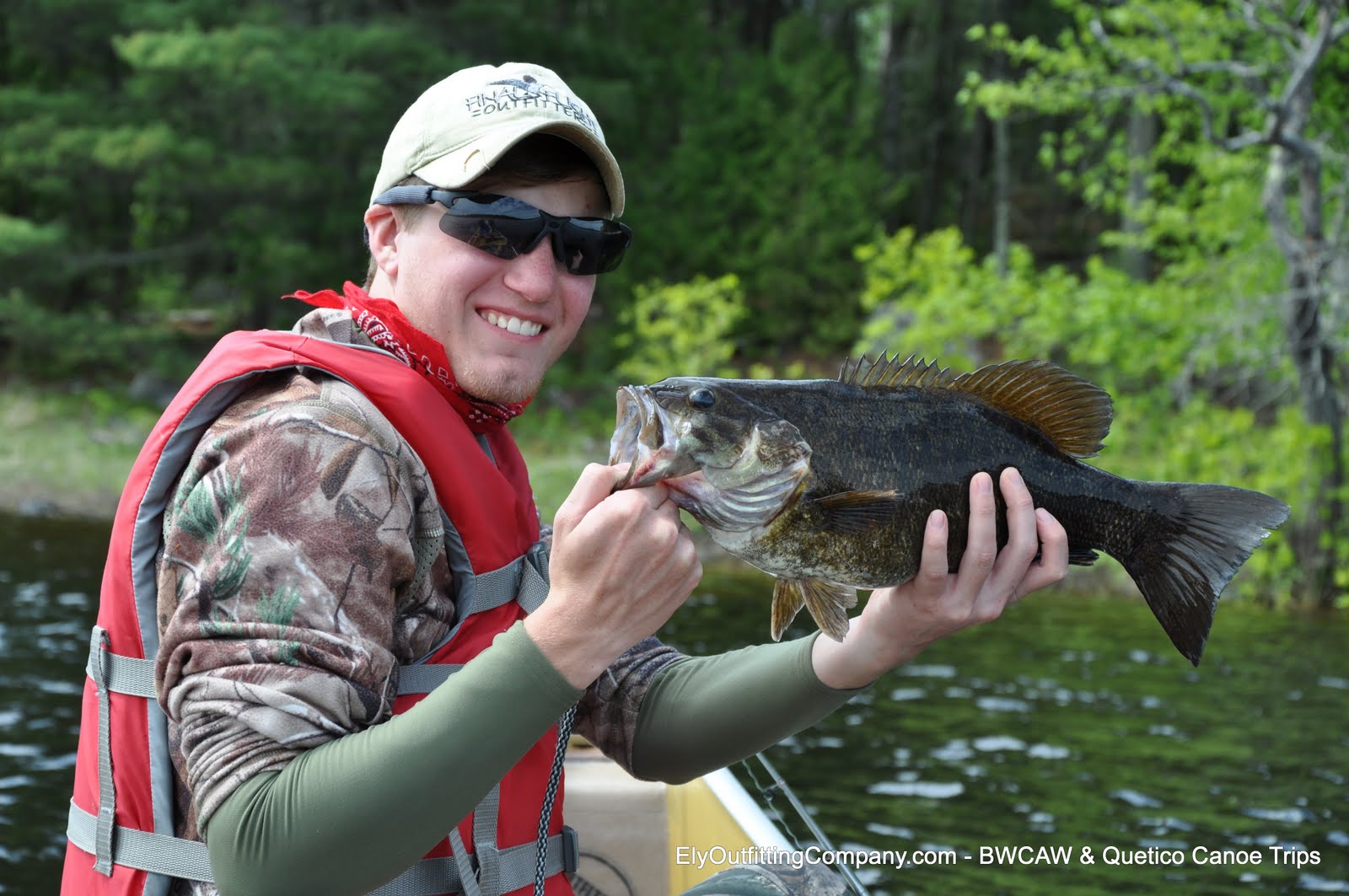
The trip involved a significant amount of portaging, and the related time for looking at the plants along the trail. But, we also spent a significant amount of time ramping up North Woods fishing skills, and wetting lines. Gary didn't catch a fish on the 1970 trip, and we were determined to improve on that this time around. We did. Blake pulled in this 18.5" lunker smallmouth bass on Iron Lake with a number 8 Rapala Shad Rap in perch color, and a trophy 27.5" walleye on Crooked Lake trolling another Rapala.


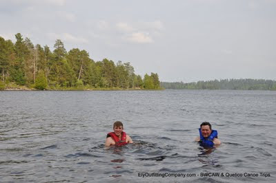
These deeper, larger lakes still held cold water temps of only about 54-55 degrees. The shallow bays and smaller lakes held warmer temps up to about 64 degrees. On the larger lakes, the smallmouth were deeper and not close to shore on their beds. The cold temps made for refreshing swims. Here are Gary and Blake at the north end of Friday Bay on Crooked Lake. The swim didn't last long.
In addition to the fish, we met some interesting critters. For example, we watched a muskrat swim under our canoe, and Blake went toe to toe with a grouse on a portage trail. Blake first thought the bird was going to attack him. She was in defender mode - defending her nest of eggs laid only a few feet off the portage trail between Bullet and Moosecamp Lakes.


We also paddled past this Canada Goose laying on her eggs atop an old beaver lodge.

A trip in the Boundary Waters is a special thing for parents to share with their children. A father-son experience, such as this one I had the privilege of guiding, can be a powerful and life-changing event. It can develop confidence and trust in one another, and provide a platform for continued sharing. It is certainly a life event that will be relived and retold at family events over the years to come.


We planned a significant travel route for the trip - one that would challenge them physically and include travel on a variety of small, medium, and large lakes. The trip launched at the Moose River North (Entry Point 16) landing, and ended six days, and fifty miles, later at the Mudro Lake entry point. One of the highlights of the route is spectacular Curtain Falls (below) on the international border.

June is a glorious time to be in the Boundary Waters. It is a time of much new growth and change. The symbol of change is similar to that of a young man transitioning from life at home to moving away for college.
One of the intriguing things about traveling at this time of year is that you see plants at all stages of development. Gary and Blake enjoyed learning about the various plants of the area. Depending on soil types and locations, we saw many plants at different stages of development. For example, we passed many Clintonia plants (below). We saw them just poking through the ground, at a stage of larger leaves, and also with their yellowish-green flowers. Later this summer the flower will be replaced by a blue berry.


Although the berry is not edible, the young leaves are edible and taste a lot like cucumber. Blake is a fan of the Survivor Man television show and enjoyed learning about edible wilderness plants, and eating them.

Another one of the interesting plants we saw at various stages of growth is the sarsaparilla plant. This is the "not poison ivy" plant. It is often confused with poison ivy because it has three leaves at the end of its stems. When it is young, the leaves have a reddish hue, and then they become green, and grow interesting spheres of flowers (below).


And the ferns ranged from the stage of youthful, unfurling fiddleheads to showing as fully opened.


We also saw a variety of spectacular wildflowers, including these bunchberry plants, now showing their white flowers....

...and these pink ladyslippers...


...and this columbine.

The trip involved a significant amount of portaging, and the related time for looking at the plants along the trail. But, we also spent a significant amount of time ramping up North Woods fishing skills, and wetting lines. Gary didn't catch a fish on the 1970 trip, and we were determined to improve on that this time around. We did. Blake pulled in this 18.5" lunker smallmouth bass on Iron Lake with a number 8 Rapala Shad Rap in perch color, and a trophy 27.5" walleye on Crooked Lake trolling another Rapala.

These deeper, larger lakes still held cold water temps of only about 54-55 degrees. The shallow bays and smaller lakes held warmer temps up to about 64 degrees. On the larger lakes, the smallmouth were deeper and not close to shore on their beds. The cold temps made for refreshing swims. Here are Gary and Blake at the north end of Friday Bay on Crooked Lake. The swim didn't last long.

In addition to the fish, we met some interesting critters. For example, we watched a muskrat swim under our canoe, and Blake went toe to toe with a grouse on a portage trail. Blake first thought the bird was going to attack him. She was in defender mode - defending her nest of eggs laid only a few feet off the portage trail between Bullet and Moosecamp Lakes.


We also paddled past this Canada Goose laying on her eggs atop an old beaver lodge.

A trip in the Boundary Waters is a special thing for parents to share with their children. A father-son experience, such as this one I had the privilege of guiding, can be a powerful and life-changing event. It can develop confidence and trust in one another, and provide a platform for continued sharing. It is certainly a life event that will be relived and retold at family events over the years to come.
Friday, June 3, 2011
"Northern Exposure" in Real Life: Moose in Ely

Many might remember television's Northern Exposure, with its wandering moose in the opening credits. Ely has its own moose, seen earlier this week walking the streets of downtown. The yellowish sign in the background with the arched lettering is Britton's Cafe on Chapman Street in downtown. Photo by Amy Kireta.
Friday, May 20, 2011
"Paddle North: Canoeing the Boundary Waters-Quetico Wilderness" Wins Top Honors
Congratulations to photographer Layne Kennedy and author Greg Breining. Their new book on our beautiful region received top honors in the General Nonfiction category at the NE Minnesota Book Awards last night.
We are exceptionally pleased to sponsor a Boundary Waters Photo Workshop with photographer Layne Kennedy on August 16-21, 2011. Space is still available. Click here for more information.

In addition to his award-winning photography skills, Layne is a gifted teacher, kind person, and fun companion on trail. Point and shoot newbies to professionals learn to take better photos while immersed in our special wilderness on the Photo Workshop.
We have copies of "Paddle North" at Ely Outfitting Company in Ely, MN. Feel free to stop in and browse through or buy a copy. They make great gifts for people who love the Boundary Waters.
We are exceptionally pleased to sponsor a Boundary Waters Photo Workshop with photographer Layne Kennedy on August 16-21, 2011. Space is still available. Click here for more information.

In addition to his award-winning photography skills, Layne is a gifted teacher, kind person, and fun companion on trail. Point and shoot newbies to professionals learn to take better photos while immersed in our special wilderness on the Photo Workshop.
We have copies of "Paddle North" at Ely Outfitting Company in Ely, MN. Feel free to stop in and browse through or buy a copy. They make great gifts for people who love the Boundary Waters.
Subscribe to:
Posts (Atom)